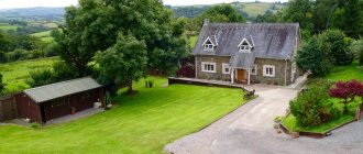
Such stories always start well: the owner stands at the border of his property and dreams of what kind of paradise he will create here. The property can be rectangular or L-shaped, or narrow, or rounded, or something completely incomprehensible - the owner has no doubt that there will be something beautiful here. And if you think everything through well, “measure it seven times,” and then build and plant, then it will be so. In this article we will look at how to plan everything correctly, how to arrange buildings on the site and will dwell in detail on the following points:
- How to do an analysis.
- What to place on the site.
- What percentage of the total area should be occupied by: house, garden, outbuildings and recreation area.
- What should be the distance between objects on the site.
- Where should the house be located, how to place the buildings.
Where to start developing a project
Any planning in construction begins with an assessment of the conditions in which it will be carried out. This stage describes the characteristics of the area being built. When planning a land plot, the owner is required to take into account:
- Surface relief. The latter can be flat, hilly, and also have ravines or large stones. All this affects the general layout of buildings and the laying of communications;
- Soil quality. It is necessary to determine the presence of a fertile layer. Or rather its depth. If it is less than 10 cm, then even lawn grass cannot be grown on such land. Additional soil delivery is required;
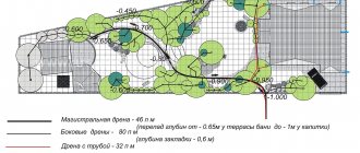
- Availability of groundwater. If their level is high, it is necessary to include a drainage system in the plan;
- Climate. Depending on the climate zone, the composition of plantings should be carefully selected;
- Size, shape. Depending on the shape and size, the landscape design of the site will be developed.
You can find out even more about private houses on the website https://masterinterera.ru/doma
How to do the analysis
Here are several options for planning country estates of various shapes, made by FORUMHOUSE member, landscape designer Alexander Zhukov. As already mentioned, with the correct placement of objects you can make a “candy” out of anything.
Alexander Zhukov Landscape designer, member of FORUMHOUSE
It is also very important to choose the design time. During the May-October season, landscapers have a lot of work to do, so the project timeline increases significantly. The most optimal period is November-March. In a calm atmosphere, slowly, thoughtfully, we do the project.
But whether you plan on your own or invite specialists, the very first step towards a future plan is this: draw the shape of the areas on a sheet of graph paper to scale and schematically mark the surroundings: “forest”, “neighbors”, “road”, etc.
Anton Lyubavin member of FORUMHOUSE
First of all, we must find out the boundaries of the site and see it on a piece of paper - preferably on graph paper with a real scale. So that you can draw everything out with a pencil and a ruler, turn on your imagination.
We can begin further work on the plan when we know our domain like the back of our hand. Having done the analysis, we will be able to avoid making offensive mistakes and provide for the location of objects on the site in the most suitable places for them.
It is usually recommended to carefully study satellite imagery and spend several days in a row on a new site in order to understand where the sun rises and sets, where the wind usually blows from, how the neighbors’ house is located, whether the place that you have chosen for a recreation area will be located directly under their windows, whether the shadow of neighboring outbuildings falls on your future garden, etc.
Also, for a full analysis you will have to:
1. Determine the relief.
You will need information about the direction and size of the slope, and in most cases for this you can do without high technology and contacting specialists. The slope level can be determined using a camera tripod and a Chinese laser pointer. The topic on FORUMHOUSE examines in detail the technology of topographic survey of a site with your own hands and available tools.
Skisa
At the suggestion of forum members, my husband and I stupidly measured everything with a tape measure. As for the differences in height, it was immediately clear to me where the top was and where the bottom was. The slope was gentle. I measured it by eye using a laser pointer and drew a line on the plan.
These lines on the plan will give us an idea of where the flows of melt and storm water will go, where the soil will warm up best, where it is better to locate buildings and where to lay out beds.
A cozy southern slope is a real gift for an amateur gardener; it is the southern slope that is the best place for growing most fruit and ornamental crops. The northern slopes warm up the worst; usually such a plot of land is terraced, with terraces sloping from west to east. If there is a need for drainage, open side ditches are made along the terraces where water can be directed.
It is better to place the house at the top of the slope and so that its shadow does not fall on the future garden or vegetable garden.
The ground is completely flat, like a table, which is more of a minus than a plus.
The optimal slope is 0.04% (at least 4 cm per 10 meters).
Therefore, on a flat plot of land, artificial terrain with a southern, eastern or western slope is most often created. The slope is made using soil from foundation pits, holes for a pond, pool, well, etc. The vertical layout of the site removes excess water from the foundations of buildings and does not deprive the garden and garden of moisture.
2. Determine the groundwater level.
Vitanik
If you don’t have the desire/opportunity to order geology, then take a garden drill (preferably two meters long) and drill in the right place. Choose the soil and see where the water is (it may not come right away). Well, by looking at the cut you can manually determine what kind of soil you have.
Methods for determining groundwater level are discussed in detail at FORUMHOUSE.
In the spring, information about groundwater level obtained by these methods will be unreliable; it is better to carry out drilling work in July and August. If the distance from the soil surface to the water level is less than a meter, you will need drainage measures. Since one of the best ways to optimize is the construction of an artificial reservoir, put it on the plan of your land plot indicating the approximate dimensions.
3. Determine the composition of the soil.
We told you how to do simple tests at home that will give you fairly accurate information about the mechanical composition and acidity of the soil. You will need this information when planning plantings.
4. If there are already trees and shrubs, indicate in the plan which ones you will leave.
Large trees in the north side do not cast a shadow on cultivated plants and protect the plantings from the wind. It is not recommended to remove them.
5. Study how your property is illuminated by the sun - this will help you correctly position buildings, choose plants and design a greenhouse.
Planning techniques
When developing a project, various methods are used. The most common are:
Geometric. Used on smooth surfaces. Distinctive features are the geometric arrangement of buildings and plantings, as well as clear, even boundaries of all landscape elements.
For example, trees, bushes, and flower beds are arranged in the shape of rectangles or squares with even borders. It is also possible to plant plants in the form of other geometric shapes that correspond to the general style of the plan.
Landscape. Used when the ground surface is uneven. The arrangement of buildings and plants does not follow clear lines. On the contrary, asymmetry is used in the design of the entire exterior. For example, ravines and hills are preserved or created, paths are laid in curved lines, trees and plants are planted according to the owner’s imagination, rather than geometric shapes.
With this site planning scheme, all artificial elements are organically integrated into the natural landscape, which allows you to create a more natural design.
Mixed. Combines landscape and geometric features in different proportions. It does not have clear rules of construction. Most popular among dacha owners.
What to consider when purchasing?
Purchasing any real estate is a responsible step that requires a lot of attention. In the case of a townhouse, it has certain features that also need to be taken into account when making the final decision.
We have prepared a small checklist: what you need to check before buying a townhouse:
1. The distance of the complex from the city, your work, schools, shops and clinics
Please note that now you will have to travel to the places where you are used to going. Sometimes quite far.
2. Availability of infrastructure, access roads, public transport
This is a continuation of the previous point. To go somewhere, there must be roads and transport. Or every family member has a car.
3. Proximity to railways and busy highways
It's noisy and a potential hazard for your children and pets.
4. Ecology
Check the environmental situation. There should be no large industries and enterprises in the district that pollute air and water.
5. Quality of house materials
Find out what materials are used in the construction of a townhouse. The comfort of future residents depends on this.
6. Layout, interior decoration, need for repairs
It is important to understand how long it will take for you to move into your new home, what additional expenses will be required for the arrangement, and how comfortable the space inside the house will be.
7. In addition
If the purchase occurs during the construction stage, check the reputation of the developer and project documentation. Meet the residents of the area - find out how everything works there and what everyday problems they face. It is possible that an unscrupulous developer may keep silent about something.
Dividing the site into zones
After choosing a technique, you should start zoning. When creating a project, the following are usually distinguished: a residential area, a recreation area, auxiliary buildings, green spaces and a vegetable garden.
10% of the entire territory is usually allocated for residential buildings, 75% for plants and beds, the remaining 15% of the area is allocated for utility buildings, recreation areas, paths and decorative elements.
Is it possible to register a house if the property line is less than 3 meters away?
We found out from the cadastral engineers what the situation is with cadastral registration if the setbacks from the boundaries of the land plot are not observed. Rosreestr, when registering real estate, was previously quite loyal to non-compliance with borders; no one checked them. However, the rules are changing and in 2021 registration is often suspended. Then the owner goes to court to register the building.
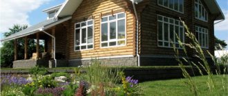
Living sector
In a planning project, the most important thing is the location of the house. If the land plot has a simple rectangular shape, then the house is located based on the convenience of access or for aesthetic reasons.
With a non-standard shape, the choice of the optimal location depends on several factors. For example, if the plot has a narrow, long shape, then the house is built with its end facing the main entrance. And when the landscape slopes, the structure is placed on a hill. This prevents flooding of the foundation and basements.
The procedure for transferring land
Plots that belong to partnerships can be re-registered as individual housing construction, but the whole process will depend on individual factors.
They can have a positive impact, which will allow the registration to proceed easily and simply, or a negative impact – the procedure will take time, additional documents will be required, and so on.
Factors influencing the difficulty of category translation:
- Location of the site. If the land is located far from residential areas and there are no communications, then translation will be difficult.
- Infrastructure. It must be sufficiently developed for comfortable living on a permanent basis.
- Other factors. They are determined in each situation individually.
After determining the chances of transfer, you must go to the municipal administration to express a desire to change the assignment.
For this you will need the following documents:
- Application with a request to change the category of land to another.
- Notarial consent of each owner, if there are several of them, or each of the owners draws up a separate application. In the second case, the personal presence of each owner will be required.
- Cadastral documentation.
- Technical documentation.
- To confirm ownership of the site.
- Extract from the Unified State Register.
- To provide complete information about the site.
After all documentation has been submitted to the administration, the application is considered within one month. The response is sent to the applicant in writing.
Upon receipt of a positive decision, an act on the possibility of transferring the site to another category is attached to the letter. But even in this case, when drawing up and executing the act, a refusal may be given, which must be justified in writing.
If the house, which is being built on the territory of a site owned by SNT, will be used only for temporary residence, then in this case there is no point in changing the category. SNT prohibits registration and residence on a permanent basis, but there are no prohibiting acts regarding temporary stay.
Grounds for refusal
Reasons for refusal to transfer a site to another category:
- a transfer ban has been imposed on the site;
- the site is not suitable for territory development;
- there is no possibility of joining a specific locality, which does not allow assigning an address, making changes to the development plan, and so on.
There is one place in the suburbs of Vladivostok. One large massif is surrounded by hills, and in the middle there is a lowland. I went there to choose land and it seems I chose it. But can I pull it off?
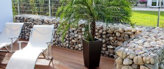
Auxiliary buildings
Owners of plots with a bathhouse and a garage must place their buildings wisely. The location for the garage is selected depending on the access roads. For safety reasons, it is advisable to locate the garage on the other side of the playground. Also learn about awnings.
The bathhouse should not be in front of the house. The best option would be a remote corner of the site, hidden from the street by trees. It is better to build all auxiliary buildings for utility purposes closer to the fence and hide them with bushes.
Types and uses of garden rakesNew Year in the yard: how to beautifully decorate the yard with your own hands!
- How to make a modern landscape design with your own hands?
Dangers of territory development.
I bought a plot of land overlooking a field, and a residential complex was built there.
Such cases are not uncommon! Especially in the nearest suburbs. When choosing a site, be wary of choosing villages near large fields, especially if they are located near cities. There is a high probability that sooner or later something will be built on this field. Okay, if it’s a cottage community or SNT, which is also unpleasant, but what if it’s a high-rise building or an industrial enterprise? In our country anything can happen. And agricultural land is very easily converted into land for development. Try to choose plots in villages that border not on a field, but on a forest, or on a large body of water on one side and a forest on the other. Forest lands and water protection zones are very strictly monitored, and it is very difficult to transfer them to another category. Ideally, find an area bordering a forest or pond and having its own access to it. It's convenient and beautiful.
In any case, try to find a recent general plan for the area, and if there is none, always look at the cadastral map. Very often you can see there that a beautiful empty field has already been demarcated into areas for SNT or KP. If you do not like such a future neighborhood, avoid purchasing such plots.
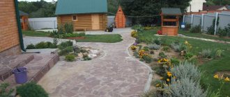
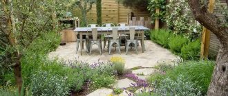
Plants and vegetable garden
After working out the building plan, you can move on to placing green spaces. It is better to locate the area for crop production on the south side.
But it is necessary to take into account that the buildings will provide shade. In such places it is not recommended to plant beds for vegetables and fruits. The placement of ornamental plants depends only on the owner’s imagination and the design project.
When and why were the standards for indentation from the boundaries of a land plot invented?
Information on how much to retreat from the fence, from the streets, from neighboring plots and erected buildings during the construction of a house is contained in urban planning and norms and regulations (SNIPs, SanPins), and is also enshrined in the law on fire safety. These norms were developed back in the last century for the safety of citizens, when private property did not yet exist. Over time, taking into account the development and development of territories, the norms and rules have changed along with other land legislation. There are sets of rules that regulate the construction of buildings within the city (SP 30-102-99). There are rules that provide for the development and planning of summer cottages (SP 53.13330.2019). Along with these codes, Sanitary Rules were adopted, which indicate the permissible minimum distances from gas pipelines, farms, wastewater treatment plants to individual buildings (SanPin 2.2.1/2.1.1.1200-03), as well as requirements for fire safety clearances (123-FZ dated July 22, 2008 g., as amended from April 30, 2021 No. 117-FZ, SP 4.13130.2013) Let's consider what rules and regulations for minimum setbacks from the boundaries of the site apply when building a house on dacha and garden plots in SNT.
Recommendations from experts
When planning, we recommend taking advice from builders and designers.
- To protect the backyard from prying eyes, you can locate the house directly on the border with the street;
- If the site has a slope, then the house is placed on a hill or in the middle of the slope, and it is necessary to make bedding;
- Trees are not planted close to the house. This is due to the fact that the house will be heavily shaded. There is also the possibility that, after a few years, the tree's roots could damage the foundation of the house;
- To create a favorable atmosphere, maximally protected from street sounds and dust, you should build a house in the middle or deep into the plot. And plant trees around the perimeter;
- When developing a plan, it is necessary to take into account fire safety and sanitary standards.
Planning is an individual and creative process. There are many layout options. Each of them depends not only on the landscape, geology, climate, but also on the preferences of the owner and his imagination.
The main thing to remember is that all objects and elements of the plan must be in the same style and harmoniously complement each other. Only then will your layout look like a single composition.
conclusions
The choice of the shape, location and size of the plot is, of course, a purely individual matter: what is the main advantage for one person may be considered a disadvantage for another.
Finding your ideal place to live can take a lot of time and effort. However, it is important to approach the process responsibly, taking into account not only the emotional, but also the practical aspects of purchasing land. And then the result will delight you for many years.
Did you find this article helpful? Please share it on social networks: Don't forget to bookmark the Nedvio website. We talk about construction, renovation, and country real estate in an interesting, useful and understandable way.
Top 5 causes of conflicts between neighbors
No matter how comfortable your apartment is, living in it will not be very comfortable if you are not friends with your own neighbors. Unfortunately, not all neighbors behave appropriately and comply with the so-called rules of the community.
This is interesting: Submitting a boundary plan to Rosreestr
According to analysts, last year approximately 20% of the conflicts that broke out between neighbors of apartment buildings in Russia ended in litigation. What circumstances most often become the reasons for hostility between neighbors?