Groundwater is an important source of water supply, especially for small settlements. They are extracted using wells, shallow wells, capturing springs and wells in places where they come to the surface. The proximity of groundwater is a potential reason for the gradual destruction of above-ground structures. During snowmelt and heavy rainfall, it floods the basements of houses, cellars and ground floors. Prolonged contact with excess moisture leads to the destruction of road surfaces, subsidence of buildings, entire neighborhoods and entire cities.
Modern megacities are also negatively affected by the pumping of groundwater, which is carried out during mass development. A dangerous trend is being observed around the world. Multimillion-dollar Beijing is sinking at a rate of 11 cm per year, but California is rapidly overtaking it, reaching a record 40-60 cm. The enormous weight of buildings and the depletion of underground water reserves have led to the soil being crushed like a wrung out sponge.
What it is?
First you need to define the concept. Groundwater is the upper layer of water from the surface of the earth.
Their level is high if they lie at a depth of up to two meters from the ground surface. This is not difficult to determine.
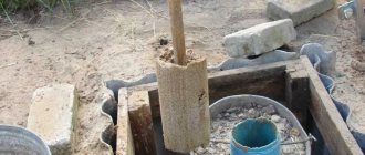
It is enough to drill a well a couple of meters deep with a hand-held garden drill in several places on the site and wait a day or two. If the level is high, the well will inevitably fill with water.
This needs to be done in the spring, since it is then that groundwater is closest to the surface due to intense snow melting.
If the drilled well is dry, then there are no problems , you can calmly lay the foundation for the house or lay communications.
If water is visible, it is better to wait a while and first artificially reduce its level by installing drainage.
How to reduce and drain high groundwater
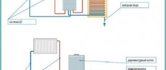
Open drainage is the easiest way to drain water from a site. First, a pit is dug, and if moisture begins to flow from the walls and bottom, it is accumulated in drainage ditches and then pumped out. The option is working, but massive withdrawal of groundwater leads to soil subsidence, so before using it, consultation with a specialist is required.
In areas prone to waterlogging, drainage systems are actively used. To drain the water, a trench is laid around the site, where groundwater will gradually flow out. Then it is pumped out and taken away. It is more difficult and expensive to organize pipe drainage. For this purpose, special polymer pipes with perforated walls are buried in ditches throughout the area. They need to be laid at a slope of several degrees so that the water flows by gravity into the prepared catch basins. In addition to pipes, sand traps and inspection wells will have to be installed for convenient maintenance of the system.
A clear example of the fight against high groundwater level is the construction of the city of Chicago on the shores of Lake Michigan. To build the high-rises, engineers used deep pile foundations driven into basalt. Already built houses and entire streets were raised with the help of hundreds of jacks to a height of up to 2.5 meters
The most expensive way to get rid of groundwater is to use wellpoint systems. The pipes are buried vertically into the ground and, using pumps, are brought out to a depth of 5-20 meters, depending on the type of installation. The specific method of reducing groundwater level depends on the type of soil and filtration coefficient (water transmission rate).
Difference from perched water
Verkhovodka is a local accumulation of groundwater located above the groundwater level. This is due to the seasonal factor and is temporary. This is precisely what makes it different.
During certain periods (for example, heavy rains or heavy snowmelt), this phenomenon is noticeable and noticeable, and during the dry period, it almost completely disappears.
The groundwater level is also subject to slight fluctuations, but not so significant, and this layer cannot completely disappear.
There is no high water on slopes and sandy areas, because in these cases there are opportunities for its natural removal.
Signs that the site has a high groundwater level
No area is immune from the negative influence of groundwater. In order to take timely measures to protect buildings, wells and plantings, the owner needs to monitor their condition. The proximity of water is indicated by high humidity in the house, the appearance of damp spots and fungal colonies on the walls. Most trees wither and dry out due to the fact that the root system is constantly in water. It is not so much moisture that is harmful to plants and concrete foundations as the salts dissolved in it.
Contact with groundwater leads to the appearance of ettringite, or as it is also called “cement bacillus”. Gradually, the cement base loses its strength and becomes loosened.
Signs of ettringitis:
- The appearance of a whitish influx of small crystals on the surface;
- Protrusion of salt stains;
- Peeling and crumbling of concrete.
When buying a house, you should definitely check the condition of the walls and floor of the basement. If the use of measures to reduce and drain groundwater on a site is impossible, builders recommend building simple houses without a basement, and building above-ground storage facilities in a mound of soil rather than underground cellars as a reservoir for storing food.
What can you do to dry it out?
Since this phenomenon is not uncommon, there are several proven options for artificially lowering the water level.
All of them are associated with a significant amount of excavation work, so it is more advisable to carry them out before laying the foundation for the house at the beginning of construction.
The following methods are distinguished:
- A reservoir or pond for storing excess moisture.
- Open drainage.
- Closed drainage system.
- Construction industrial dewatering using wellpoints.
What is an aquifer map?
Hydrogeological study of soils makes it possible to determine the types and characteristics of soil layers in a small area or a large area, as well as the level of groundwater. Based on the study and analysis of the results, a number of documents are compiled. As a rule, local archives of settlements have long had geological sections and maps of aquifers. But outside the city or on newly developed sites, it is necessary to excavate soil samples and determine the location of underground levels of water surfaces.
Underground water behaves somewhat differently than in a container, where there is no doubt about the horizontalness of its level. In the thickness of the soil, the line of the water table can bend under the influence of many factors:
- terrain;
- shape and placement of waterproof layers;
- make-up and reset options;
- throughput and density of soil layers;
- proximity to bodies of water, etc.
When compiling maps, they use groundwater level measurements from available natural and artificial sources. These can be wells and workings, wells and pits, water bodies and water-measuring posts. To ensure the “purity” of the data obtained, measurements at points located close to each other are carried out on the same day due to the fact that the groundwater level can change significantly under the influence of external influences. In this regard, maps of aquifers must be dated.
If, when developing a site, groundwater can be detected during the construction of a pit, then when constructing a mine well or artesian well, specialists will need to look at the map of aquifers. Its absence in most cases leads to unforeseen situations. For example, during the process of lowering well rings, it may turn out that the water is much deeper than the expected level. The meaning in further work will disappear by itself, and the rings will most likely remain in the ground. In this case, it would be more profitable to immediately stop at constructing a well.
Experienced professionals recommend not to neglect familiarization with maps of aquifers or carrying out exploration drilling. By the way, you can determine the proximity of an aquifer using traditional methods, but this does not always lead to the detection of drinking water.
How to correctly calculate the drainage of a site according to SNiP?
When constructing and calculating drainage on your site, it is recommended to follow the requirements of the relevant regulatory documents.
In relation to the topic of the article, you need to pay attention to SNiP (an abbreviation for Building Norms and Rules) 2.06.15-85 “Engineering protection of the territory from flooding and flooding”, as well as SP 250.1325800.2016 “Buildings and structures. Protection from groundwater."
SNiP clearly defines all stages of drainage creation:
- Project in which system data should be specified:
- general scheme.
- geometric data: trench parameters, their slope, distance between system elements.
- diameters of pipes used, parameters of wells.
- fasteners, materials for filling drainage trenches and pipes.
- Cleaning the area where drainage will be laid.
- Digging trenches taking into account how much the soil freezes in a particular area.
- Strengthening walls with gravel or polymer materials
- Laying of pipes, if used, taking into account the permissible material, as well as the laying depth in accordance with SNiP.
- Digging drainage wells or septic tanks, calculating the permissible angle relative to ditches or closed drainages.
Groundwater conditions
According to the conditions of occurrence, the following types of groundwater are usually distinguished:
Perched waters
. Verkhodka is underground water that lies at a shallow depth in the aeration zone - the zone of free penetration of air. Typically, perched water does not have a continuous distribution, but forms relatively small lenses that are underlain by water-resistant rocks (Fig. 23). The thickness of such lenses of perched water usually does not exceed 0.5-1 m, less often it reaches 2-3 m. Here the water is already in gravitational form and has a level. The water level of perched water is subject to significant fluctuations, which explains its disappearance in wells in areas with arid climates.
Groundwater.
Atmospheric waters, seeping from top to bottom to the aquitard, and then moving horizontally, gradually fill all the voids in the rock. This is how aquifers arise (Fig. 23).
aquifer
called a layer or layer of rock in which the pores, voids and cracks are filled with water.
Each such layer has a roof and a base. If the formation is not completely filled with water, then the aquifer refers to only its water-saturated part. The first permanent aquifer from the earth's surface is called the groundwater horizon
.
Groundwater has a free surface - a mirror
, or
groundwater level.
This level is not constant. It usually rises during rainy periods and decreases during dry periods. If the groundwater level in some area rises to the earth's surface, a swamp forms here.
In general, groundwater is characterized by the presence of a free water surface - a level, the presence of only one, underlying, aquifer, and the absence of pressure.
Interstratal (formational) waters
. The difference between interstratal waters lies primarily in the fact that they are contained between two aquitards, that is, they are limited by them both from above (from the roof side) and from below (from the bottom side). Aquifers containing interstratal waters are usually characterized by a wide distribution area, often measured in thousands of square kilometers. Moreover, they lie at a considerable depth, emerging to the surface only at the periphery.
Groundwater together with its host rocks form hydrodynamic systems
, which are divided into non-pressure and pressure.
Gravity
hydrodynamic systems are usually characteristic of groundwater basins that do not have natural pressure.
Within pressure
systems, atmospheric water enters the permeable formation in areas where it is exposed at the surface, in the so-called
recharge area .
Gradually, atmospheric moisture penetrates deeper and completely saturates the entire layer.
Moving along the formation, water reaches other areas where it comes to the surface and flows out on its own, forming sources of groundwater. This is an area of discharge
, or
drainage
of formation water. Depending on the relief and altitudinal position of the feeding and unloading areas in the central, most deflected part of the basin, conditions may exist that are favorable for creating pressure, i.e. spontaneous outpouring of water under pressure (Fig. 24, a).
Thus, in the central part of the basin an area is formed
pressure within which water from wells can flow out in the form of a fountain. The height of water rise depends on the location of the wells relative to the feeding and drainage areas and on the hydrostatic level.
Hydrostatic (piezometric) level
called an imaginary surface passing through the area of feeding and discharge and determining the height of the rise of water in a given place (Fig. 24). Piezometric level is usually expressed in absolute terms relative to sea level. Artesian water cannot rise above this level when gushing.
Another characteristic of the pressure area is hydrostatic (piezometric) pressure
, which is understood as the height of the water column from the top of the aquifer to the piezometric level. Piezometric head is expressed in meters.
How do heated substances affect the base?
The supporting foundation is clay, loam or rock. If for the latter the chemical composition is usually not very critical, then the water indicator can have a serious impact on sedimentary layers. Dry clay is strong and not prone to deformation. Saturation with liquid leads to an increase in plasticity and a sharp decrease in load-bearing properties. As an example, seasonal muddy roads in central Russia.
A fairly common phenomenon is karst cavities formed when precipitation penetrates into the limestone zone. Such caves (which have lost their strength over time) are capable of “absorbing” entire high-rise buildings.
Purity
Recently, people have begun to think about the quality of water in the upper layer at the state level. Due to the high intensity of economic activity, the most exotic pollutants penetrate into the springs. As a result of the work of agricultural enterprises, fertilizers, pesticides and decomposition products from farms enter it. Industrial pollutants are considered more dangerous, since they are difficult to process naturally and contain salts of heavy metals. One of the problems is the presence of protozoan microorganisms and viruses. Thanks to organic matter and oxygen, water from wells and springs has a large number of bacteria.
Where are they used?
This resource is widely used to meet household needs. In each settlement, a shallow mine is dug near the house to use water in the kitchen and for watering plants. Due to strong differences in taste, housewives prefer to take moisture for cooking from certain points. That is, the chemical composition can be different even on the same street.
In industrial quantities, use is limited due to seasonal level changes and low power. In most cases, the amount of dissolved impurities does not meet the standards. In addition, overly active exploitation can disrupt the natural water balance, and thereby affect the nature of vegetation in the area, since part of the flora receives nutrition from great depths.
Inspection of nearby wells
Another quick way to find out how close groundwater is is to get to know your neighbors. Find a residential building nearby, preferably not a new building, and ask the owners a question. Over the years of living in this territory, they have learned for sure whether this problem exists here and will probably agree to show you a well or tell you about the presence of water in the cellar in the spring.
By the way, in areas where foundation work has just begun, so-called “technical wells” are most often made for construction needs. The water mirror is also clearly visible in them.
How to determine groundwater level
Advice: The most reliable information when determining groundwater level should be obtained in the off-season, when the amount of precipitation is maximum. This is in spring or autumn, when snow melts or frequent rains, respectively.
There are many ways to determine groundwater level:
- Geobotanical.
In this case, you should pay attention to how plants grow and develop depending on a particular water level and terrain features. There are special tables that list plants that are most common on certain soils and develop differently on soils with different degrees of moisture. But this method is quite lengthy, which is not always suitable for site owners, especially if there is no specific knowledge.
- By wells.
GWL, or seasonal fluctuations in levels, is determined by marks made inside the well. These marks are always there; they are left on the concrete by water. In this case, the following are determined:
- highest point;
- fluid level at the time of checking;
- in hot weather in summer
It is noted how far these levels are from ground level. This is also a difficult job that geoexploration beginners cannot do.
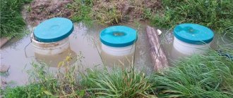
- Drilling a well.
This is the fastest and easiest way. In this case, a well is drilled in the soil at least two meters deep, and it is monitored for five days. A gradual rise of water at the bottom of the well indicates a high groundwater level, which can increase with precipitation. But if after five days the well is dry, there is no need to worry.
Aggressiveness
Its chemical composition also depends on where the groundwater is located. If a pure liquid has fairly predictable properties and its effects are easy to resist, then dissolved salts, acids and other trace elements seriously change the activity of the solution. Because of this, the corrosion properties and dissolving abilities differ. This must be taken into account when constructing buildings and communications.
In temperate climate zones, serious attention is paid to the freezing properties of soils saturated with water. Since the forces arising in this case are very large and can destroy the concrete foundation or deform the steel pipe in the freezing area.
Calcium and magnesium impurities tend to settle on metal and other surfaces when heated. This threatens to quickly destroy expensive equipment. Therefore, it is necessary to use a cleaning system. The quality of the liquid can be very different and prone to seasonal changes. You can pick up a filter kit in a specialized one. After processing, all characteristics will return to normal.