The terrain does not always allow you to build a reliable house without making adjustments to the natural landscape.
Sharp slopes threaten flooding, washing out of fertile soil, and destruction of the house.
To adapt the territory for comfortable living, a vertical layout of the land plot is used before construction.
Why do they change a flat surface, who carries out geodetic work, is it possible to calculate the differences in the ground yourself - read about the intricacies of vertical design in this article.
What it is?
Vertical layout (VP) of a land plot - preparation for artificial transformation of the natural terrain , preparatory stage of construction.
Work begins with geodetic measures to determine the coordinates and heights of surface points and spatial objects. Sometimes it is enough just to determine the actual height difference.
Based on the research results, it is concluded how much the surface is deviated from the ideal horizontal.
At the next stage, it is assessed how high the groundwater lies and how much the soil swells from low temperatures.
Before vertical planning, preparatory work is completed, unnecessary soil and vegetation layer, trees and shrubs are removed.
Planning objectives are to optimally adapt the land for construction and living :
- level the terrain;
- highlight zones with slopes;
- determine places for arranging slopes, stairs, terraces;
- reduce the groundwater level, create effective drainage;
- provide optimal conditions for plants;
- combine the zones of the site with a single architectural and stylistic idea;
- outline the lines for laying underground communications.
Artificial relief is created during excavation work: softening slopes, cutting or adding soil, constructing local embankments.
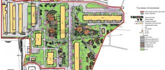
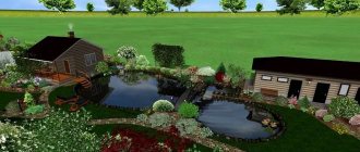
Dividing the site into zones
After choosing a technique, you should start zoning. When creating a project, the following are usually distinguished: a residential area, a recreation area, auxiliary buildings, green spaces and a vegetable garden.
10% of the entire territory is usually allocated for residential buildings, 75% for plants and beds, the remaining 15% of the area is allocated for utility buildings, recreation areas, paths and decorative elements.
Planning principles
Vertical planning is carried out taking into account the preservation of the natural environment :
- maximum preservation of natural relief, soil and existing flora;
- drainage of surface water at a rate that prevents soil erosion;
- minimum excavation work using excavated soil at the construction site.
Other principles of correct EP that guide the developer when carrying out upcoming excavation work:
- Saving . VP is a costly undertaking that requires the involvement of surveyors, engineers, and rental of special equipment. To avoid unnecessary expenses, follow a well-thought-out plan, with minimal use of natural and technical resources.
- Maintaining a balance of earth masses . His rule: the volume of the withdrawn land mass should practically correspond to the volume of bedding on the site being developed.
- Individual approach . When VP, averaging and standard solutions cannot be used - in addition to the wishes of the owner, the features of a specific landscape are taken into account.
Design project
Any site should be not only convenient, but also beautiful. Therefore, territory planning is usually carried out with the simultaneous preparation of a design project. In suburban construction, when decorating the local area, two styles are most often used:
- Landscape. In another way, this direction is also called picturesque. In this case, plants are placed without following strict rules, paths can be curving, and landscape elements are arranged naturally.
- Geometric. This style is usually chosen for areas located on level ground. Its characteristic features are precision of lines and shapes, strict geometry.
Regulations
When designing and constructing residential buildings, they are guided by the standards SP 55.13330.2016 “Single-apartment residential buildings.” The construction of cottages is carried out in accordance with the requirements of “Planning and development of the territory of gardening by citizens. Buildings and constructions".
Development of design documentation for private development is carried out on the basis of SP 11-111-99. In addition, during the construction of objects they rely on the Land and Town Planning Codes of the Russian Federation, as well as other sets of rules (SP) :
SP 45.13330.2017 “Earth structures, foundations and foundations”;- SP 42.13330.2016 “Code of rules. Urban planning";
- SP 82.13330.2016 “Improvement of territories”;
- SP 126.13330.2017 “Geodetic work in construction”;
- SP 47.13330.2016 “Engineering surveys for construction.”
Living sector
In a planning project, the most important thing is the location of the house. If the land plot has a simple rectangular shape, then the house is located based on the convenience of access or for aesthetic reasons.
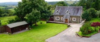
With a non-standard shape, the choice of the optimal location depends on several factors. For example, if the plot has a narrow, long shape, then the house is built with its end facing the main entrance. And when the landscape slopes, the structure is placed on a hill. This prevents flooding of the foundation and basements.
Design Goals
Before starting construction, the natural deficiencies of the area are compensated. With vertical design, the natural terrain is transformed into an artificial one, which best meets the requirements for the operation of the house and landscaping of the site.
When performing the VP, the foundations are laid for the correct planting and long-term operation of the house :
- Pits and trenches are formed for foundation structures.
- The bearing capacity of the soil at the base of the foundation increases.
- The severity of frosty rising of the ground decreases.
- Optimal conditions are created for drainage and removal of water from the foundation area: groundwater, melt, and rain.
Proper planning eliminates the visual effect of a “house in a hole.”
When carrying out excavation work to level a construction site using the bedding method:
- the permissible load on the foundation increases;
- the number of freezing layers is reduced;
- the thickness of the soil above the groundwater boundary increases;
- the impact of soil movements on the foundation under the influence of negative temperatures is reduced;
- the evacuation of rain and melt water from the construction site is improved.
Soil from pits and trenches is used for backfilling, so there is no need to remove it, spend money on disposal, or look for alternative methods of use.
What problems does it solve?
Vertical planning solves the problem of transforming the terrain according to the construction plan. As a result, the surface can be used for construction and landscaping. Excavation work consists of reducing the amount of soil (cutting) in the required places and pouring it into the depressions.
The project takes into account:
- location of the land plot, its size and number of proposed structures;
- the possibility of flooding the area and drainage of water (melt, rain, groundwater) from it;
- creation of a comfortable, safe area for residents (no sharp slopes, ditches, hills);
- the need to install underground networks;
- strengthening the soil in the place where the foundation and other structures are planned;
- measures to create conditions for growing plants.
Vertical planning of the territory is considered effective if the result is achieved with a minimum amount of land work. To do this, make a drawing in which the area is divided into parts (usually squares). Next, the points of zero work are determined where the soil line is at the required level: adding or cutting soil is not required. A line is drawn between the points under consideration, which is called the line of zero work. This is the border that separates two areas: soil is removed from one and added to the other. Particular attention is paid to calculating the volume of earth masses moved to the backfill zones.
Is it possible to get by?
If during the construction of a house VP was not carried out, or was carried out unprofessionally, the consequences can be disastrous :
- The house tilts with gradual destruction. If the site is not leveled, the load on the foundation will be distributed unevenly, which will lead to cracks, structural instability, and collapse.
- Inability to maintain a garden. Flooding that is difficult to predict is destructive to soil and crops.
- Problems of engineering communications. The eroded soil will cause damage to electrical networks, sewerage systems, and wastewater treatment plants.
- Impossibility of building a ground floor and basement: there is a high risk of flooding and collapse in the event of eroded soil movement.
- Rotting of wooden buildings under the influence of increased levels of precipitation.
Due to the washing out of the soil and the instability of the site, it becomes impossible to build light buildings: gazebos, bathhouses and sheds.
What kind of memory is absolutely necessary?
Uneven landscapes limit the developer: not all projects are suitable for implementation; the construction of a pile foundation may be required. In addition, uneven areas are susceptible to soil erosion by rain and melted snow.
Based on the relief factor and elevation changes within the boundaries of the development area, the land plots are classified as:
- smooth;
- with a slight slope: ≤0.5 m;
- with a significant slope: 0.5-1 m;
- with a steep slope: ≥1m.
Experienced builders believe that every site needs bedding: even flat areas should be raised to lower the groundwater level.
Atmospheric precipitation removal
As mentioned above, for this you will have to build a blind area and lay a drainage system.
As for the first, for this purpose, a backfill of durable soil or a mixture of sand and crushed stone 10 cm high is made around the entire perimeter of the house. That is, it is necessary to begin the construction of a winding on a site that will be higher than the plane of the main soil.
The width of the blind area is 80 cm, the angle of inclination away from the foundation is 5°. Usually it is filled with concrete mortar, but you can use asphalt or piece slab products (stone or concrete), which are laid without gaps. The main requirement for the blind area is one hundred percent water impermeability. If the soil in a suburban area is heaving, then the blind area is filled not with a single strip, but in sections with length dimensions ranging from 1.5-2.5 m.
Blind areas of a house built on an uneven plot Source www.remontnik.ru
As for the storm sewer system, first of all it is necessary to understand that before construction began, melt and rain water flowed down the elephant without encountering any obstacles on its way. The erected house on the mountain side is a huge insurmountable obstacle. Therefore, it is in this place that water will accumulate. It must be diverted skillfully, for which they use trays installed along the foundation located on the upland part of the slope, with a slight slope away from the house, but along it.
Now about deep drainage. It is constructed only if the soil on the site is sandy, but below it there is dense clay soil that does not allow water to pass through. During the rainy season, water passes through the sand, but does not penetrate the clay. An aquifer is formed, which is called perch. It is very dangerous for the foundation. Therefore, at the level of the high water, drainage pipes are laid, with the help of which water is drained.
How to do VP - stages
A land survey is carried out before construction begins in order to prepare the landscape for future development. First, pre-design work is carried out.
Geodetic topographic survey
Mandatory stage , from which the development of schemes and planning of earthworks begin.
The terrain is leveled: the height and depth of landscape elements are determined relative to the conditional zero mark. The survey is carried out by specialists using geodetic equipment. After determining the altitude position of the design surfaces of the site, the optimal option for excavation work is selected.
Geological research
At the stage of geological surveys,:
- type of soil, its characteristics;
- the level of groundwater that is dangerous for the technical condition of the future foundation;
- soil freezing indicator;
- degree of frost heaving of the soil.
Geodetic and geological information is used in the development of design plans and diagrams.
Project development
The preparation of project documentation is carried out in stages:
- Collection of information . Studying the features of the relief according to the documentation received at the stage of pre-project preparation. The assessment is carried out on the basis of a detailed topographic plan, survey of relief elevations, results of studies of the structure and composition of the soil, information about the depth of groundwater and soil freezing. If necessary, additional measurements are taken.
- Development of a planning scheme in design marks. Survey data from real and design high-altitude points and the horizontal contours of the actual relief are plotted on the topographic plan.
- Drawing up a plan for transforming the relief in design contours. The designation of lines of real and projected relief configurations is carried out using the contour method: the existing one is drawn in black, the projected one is highlighted in red. The finished plan reflects a clear picture of the upcoming soil movement activities.
- Formation of a cartogram of the movement of earth masses. The cartogram indicates the marks of the design heights and the existing relief, and identifies the zones of excavation and fill of soil.
Based on these documents, a vertical layout project is being developed.
8.Legal basis of the Russian Federation in the field of environmental protection
9. Features of the use of natural and man-made landscapes in the design of residential and public buildings.
10. Scope of application of custom-made structures
11.Layout and role of engineering equipment in providing comfortable and necessary sanitary and hygienic conditions in residential, public and industrial buildings
12.Legal framework of the Russian Federation in the field of historical and cultural heritage
13.Technical and economic feasibility study of the project, main technical and economic indicators of the project.
A feasibility study (feasibility study) is a comprehensive pre-project document compiled to assess the economic feasibility of the construction of new facilities, reconstruction or modernization of existing facilities and enterprises.
The feasibility study is based on analyzes and calculations of various indicators. To develop a feasibility study, a whole range of specialists is involved: lawyers, financiers, economists, etc.
A feasibility study is a document that is in many ways similar to a business plan, but the two concepts should not be equated. A feasibility study, unlike a business plan, does not contain an analysis of financial risks or an analysis of a marketing strategy. A feasibility study is developed to confirm the economic efficiency of the choice of proposed technologies, processes, and project solutions.
The tasks of the feasibility study include estimating the costs of implementing a construction project, calculating the payback period of the project, and its production capacity. The feasibility study also considers the issues of providing construction with the necessary raw materials, engineering and transport communications.
The feasibility study also contains an analysis of the land plot for construction. Rational use of land is of great importance for the conservation of natural resources on the site and adjacent territories - new construction or reconstruction of existing facilities have a significant impact on the environment.
The structure of the feasibility study includes calculations of the main technical and economic indicators of the enterprise (facility), calculations of the enterprise's needs for various resources (labor, raw materials, energy, etc.), an economic justification for the choice of a specific technology, production scheme, equipment.
Based on all calculations and analytical data, the feasibility study provides conclusions about the economic feasibility of implementing the project, and assesses the prospects for implementing the project.
The feasibility study, after approval, serves as the basic document for drawing up the design assignment.
Technical and economic indicators (TEI) during the construction of buildings and structures are calculated to compare structural and space-planning solutions and select the most economically advantageous of them.
Calculation of technical and economic indicators for a general site and facility construction plan may include calculation of the cost of construction facilities, calculation of the duration of work to organize construction, calculation of the cost and length of necessary roads, communication networks per 1 hectare of development.
Also, as part of the calculation of technical and economic indicators, the following coefficients are determined:
●development coefficient - the ratio of the building area to the entire area of the construction site;
●area utilization factor - the ratio of the area of the building under construction, as well as all necessary temporary structures and communications, to the total area of the construction site.
In addition to the technical and economic indicators for the construction plan, the general explanatory note in the construction organization project (COP) and the work execution project (WPP) calculates the technical and economic indicators for construction work as a whole:
●total duration of construction, including the preparatory period (mandatory indicator);
●maximum number of workers employed in the construction of the facility (recommended indicator);
●total labor costs for construction and installation work—(recommended indicator).
For the work project, the following recommended technical and economic indicators are calculated:
●volume and duration of construction and installation works;
●cost of construction and installation work compared to the estimate;
●level of mechanization and labor costs per 1m3 of volume and 1m2 of building area;
●other convenient indicators of labor productivity.
The selection of the most cost-effective solution is made by comparing the technical and economic indicators of existing solutions with the reference one or by comparing existing solutions with each other. To compare different solution options, special coefficients are calculated that determine the quality of each space-planning solution.
Also taken into account is the consumption of basic building materials, the specific labor intensity of constructing a building per 1 m2 of usable area and per 1 m3 of building volume, the building assembly factor and the weight of the building per cubic meter of volume.
Vertical planning of urban areas Lecture on the topic: Engineering organization of the territory of populated areas. Part 1: Vertical planning of urban areas. — Vertical layout. — General information about the relief. — Gradation of territories by favorability. Vertical planning of urban areas Vertical planning is an engineering measure to artificially change, transform and improve the existing terrain for use for urban planning purposes. It is mandatory and one of the most important activities for engineering preparation and landscaping. The main purpose of vertical planning is to create planned surfaces that meet the requirements of development and engineering improvement of the territory. The vertical layout of the territory is designed to create favorable conditions for the placement of buildings and structures, the laying of streets, driveways, underground utilities, etc. All these activities are associated with cutting, filling and moving earth masses. Since earthworks occupy an important place in the construction complex, both in terms of volume and cost, with vertical planning they strive to make more efficient use of the existing terrain. All land work on the territory is directly related to the organization of surface (storm and melt) water runoff, which is carried out using a territory-wide closed drainage system. It is designed in such a way as to collect all surface water runoff from the territory and divert it to possible discharge sites or treatment facilities, while preventing flooding of streets, low areas and basements of buildings and structures. Surface drainage is organized from all urban areas. For this purpose, open and closed city drainage systems are used, which remove surface runoff outside the city area or to treatment plants. The main tasks of vertical planning include: * engineering:
- organization of surface water flow (rain, storm and melt) from urban areas;
- ensuring acceptable slopes of streets, squares and intersections for safe and convenient movement of all types of urban transport and pedestrians;
- creating favorable conditions for the placement of buildings and the laying of underground utility networks;
- organization of relief in the presence of unfavorable physical and geological processes (flooding of the territory, flooding with groundwater, gully formation, etc.);
- solving problems in the construction of large and unique planar structures (sports center, airfield, etc.).
* architectural and planning:
- giving the relief the greatest architectural expressiveness;
- giving the ensemble (territory of a microdistrict, park, recreation area) a spatial composition by moving soil within the boundaries of the designed territory;
- creation, if necessary, of artificial relief.
General information about the relief Of all natural conditions, relief is the most characteristic and determines the state of the surface of urban areas. Solving many issues of engineering preparation requires a preliminary study of the natural relief and its adaptation to the requirements of construction. The terrain is depicted on the terrain plan by conventional lines - horizontal lines that connect points of equal heights in the drawing (Fig. 1). The pitch of the contours characterizes the difference in elevation between adjacent contours and is called the relief section. On a terrain plan, the existing surface is indicated by existing (black) contours, and the design surface by design (red) contours.
Rice. 1. Plan of the area with existing contours 1 - contours; 2 - thalweg; 3 - saddle The relative position of existing and designed contours determines the surface slopes and features of landforms, watershed lines and the lowest places where surface runoff is concentrated. Terrain slope - i - is expressed in ppm (10/00 = 0.001) or percentage (1% = 0.01). It is calculated between two fixed points, according to the expression: i=Δh/l where Δh is the difference in elevation between the points under consideration, m; l is the distance between the points under consideration, m. When determining the slope between two points that are not on the horizontal lines, their marks are calculated by interpolation. The marks of two horizontal lines are taken as a basis, between which a point lies. Then the mark of the point HX (Fig. 2) will be equal to: HX = HA + h1. Fig.2. Determination of relief marks Based on the complexity and features of development, the relief for various types of construction is classified according to its favorableness (Table 1). Table 1 Gradation of territories by favorability
The elevations of the planned surface are assigned in such a way as to preserve the existing relief, green spaces and soil cover as much as possible. Therefore, vertical planning is carried out mainly in areas occupied by city streets, roads and squares, as well as in areas intended for the construction of buildings and structures. Depending on the category of streets and roads, they are given longitudinal slopes permitted by SNiP 2.07.01-89* “Urban Planning. Planning and development of urban and rural settlements.” In other areas, the vertical layout should be designed taking into account the need for surface drainage, i.e. mainly in drainless areas and areas with large slopes where soil erosion is possible.
Continuation of the lecture on the topic: Engineering organization of populated areas. Part 1: Vertical planning of urban areas. Part 2: Vertical layout design methods. Part 3: Vertical layout of streets, roads, driveways and sidewalks. Part 4: Vertical layout of intersections. Part 5: Vertical layout of pedestrian paths, park alleys and paths. Part 6: Vertical layout of recreational and utility areas. Part 7: Vertical planning of interhighway areas. Part 8: Vertical planning of areas prone to flooding. Part 9: Altitude reference of buildings. (planting buildings on topography) Part 10: Vertical planning of green areas. Part 11: Organization of surface water flow.
How to make a diagram?
Land plots for construction, regardless of the topography, require accurate calculations and diagrams.
On a geodetic basis:
- indicate the location of objects;
- The design surface is marked with red lines.
Lines formed by the intersection of the base with other planes are projected onto the plane by horizontals.
The pitch is 100-500 mm, depending on the scale, conditions and complexity of the arrangement. You cannot cut off the horizontal lines; they must go through the entire plan, and the section remains unchanged. An acceptable case of contour breakage is the connection of design surfaces with slopes, walls, and fences.
If it is planned to add soil, the red lines are moved back, indicating a decrease. The area where land acquisition is planned will be elevated in the diagram.
The slope, which is constant throughout its entire length, is reflected by the equal distance of the horizontal lines from each other. The angle between the lines, indicating the marks of low terrain, indicates the ridge; in the opposite case - to the notch.
Surface water will be drained at right angles to the red lines. Horizontal lines with a closed concentric contour surrounding one another are indicated by :
- hill - the center is occupied by higher lines;
- depression - closer to the middle the lines decrease.
This information is enough to read and implement the vertical planning scheme.
Plants and vegetable garden
After working out the building plan, you can move on to placing green spaces. It is better to locate the area for crop production on the south side.
But it is necessary to take into account that the buildings will provide shade. In such places it is not recommended to plant beds for vegetables and fruits. The placement of ornamental plants depends only on the owner’s imagination and the design project.
Means, tools, equipment
To measure differences in memory and markings you will need:
- level;
- building level;
- roulette.
Geodetic work is carried out only by professionals with special equipment. Site planning (filling, cutting, moving, loosening the soil) is carried out mechanically or manually.
In the first case, heavy special equipment :
- bulldozer or grader;
- tractor with cultivator or bucket.
When working independently, a walk-behind tractor with a cultivator and a cutter for cutting soil is used.
Needed for manual work:
- shovels;
- choppers;
- rake;
- scrap;
- pegs;
- sledgehammer or hammer.
To remove trees and bushes from the area, an ax, saw, and hacksaw will be useful. To transport soil you will need a wheelbarrow.
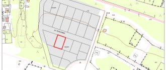
Land survey plan
Planning the territory of a land plot (private) is an officially optional procedure. It is necessary to carry out land surveying. This is an official document and only licensed companies or individuals can draw it up. Without a boundary plan, it will not be possible to register ownership of the site. The procedure for its preparation is determined by law. Previously, existing information about the site is collected. This could be, for example, old sales contracts, drawings, etc. Then the work is carried out directly on site. At the same time, the site is inspected, its area and boundaries are determined. Next, preliminary surveying is carried out. After all approvals, the boundaries of the site are finally assigned.
A completed boundary plan is a mandatory part of the package of documents submitted to the Cadastral Chamber. In addition, for registration, a technical passport is required, which contains information about the buildings located on the territory, a document confirming ownership, etc. After being entered into the register, the site is considered legally registered. This makes it possible to carry out purchase and sale transactions in relation to it, draw up gift agreements, etc.
Tips for different terrains
It is advisable to place the house in the highest part of the site. In order for the foundation to be above groundwater, methods without deepening (or with minimal) are used.
Sometimes technical issues hinder such methods: a heavy structure is designed, a movable top layer. In these cases, an optimal compromise solution is selected - and only with the involvement of specialists.
Then a blind area is performed, and trays are installed to remove surface water. A well-thought-out topography should drain precipitation and melt water into a water intake: a ditch, a reservoir . Groundwater is drained from the site using deep drains into drainage wells.
If the house is located on a hillside, the terracing method is used - creating several levels (steps) based on the principle of a staircase. When constructing terraces, soil is added, slopes are strengthened, and retaining elements are installed. The terraces look beautiful, effectively remove moisture, and on each of the “steps” you can arrange a small garden. Terracing has one significant disadvantage - the high cost of the work.
Relief is an important component of the landscape. Its features determine the planning and compositional solution of the object. With flat terrain, landscape designers recommend adding expressiveness to the overall composition. Artificial microrelief is created by slides, retaining walls, and dumps.
Flat territory
Often, flat areas are located in lowlands, where high groundwater levels, accumulation of rainwater and melted snow cause rapid waterlogging. Before construction, a low embankment is made and a shallow foundation is laid. The thickness of the soil backfill is 20-50 cm.
Soil (soil with plant and other organic elements) cannot be used; clean, dense material is needed.
The poured area around the perimeter is compacted with a sand-gravel mixture.
An example of a flat area in the diagram below:
- Blind area. Width 1 m, slope 3 cm/m. A greater slope is not recommended: the blind area will be uncomfortable for walking, and in winter – slippery and dangerous. For comfortable movement, internal corners are cut at an angle of 450.
- Water dispersal area. Width 2 m, slope 2 cm/m. If you form a larger slope, the fertile layer will be washed away.
- Slope area for water drainage. Width 5 m, slope 1 cm/m.
- Water discharge area. Slope 1-5 cm/m.
With a slope
If the height difference within the boundaries of the future foundation does not exceed a meter, fills are made for leveling. In this case, the soles of the base lobes should be on the same line horizontally (with a slight deviation).
No more than 0.4 m
If the slope is less than 0.41 m, the entire site is leveled to a horizontal level. The above-ground portion of the plinths is located at the same height.
From 0.4 to 1 m
When the difference in height of the natural relief is more than 0.40, but less than 1 m, new portions of soil are not poured into the horizon, limiting themselves to artificially lowering the unevenness.
Over 1 m
A basement is being designed on a site with such unevenness. Drainage is installed on the ground floor. Not every developer is able to carry out proper planning in such non-standard conditions; it is better to turn to professionals. They will diagnose the area, study the composition of the soil and the depth of groundwater.
Nuances by geographical location
It is important to consider the following points:
If the landscape is flat, the location of the house and green spaces requires minimal financial and time costs.
As a rule, slight slopes are arranged near the walls to drain water to the boundaries of the site. Slopes are formed using a soil embankment.- Areas sloping south are characterized by oversaturation of vegetation. Such reliefs are ideal for arranging green areas. The ideal place to build a house is considered to be the highest point closer to the eastern border of the site.
- Areas where the terrain slopes towards the east and west have their own characteristics. It is better to locate buildings near the northern borders to avoid shadows on plants.
- Areas with a steep slope to the north require a reliable drainage system.
Subtleties that you should pay attention to when planning vertically
After taking measurements, specialists begin work on creating a plan. Their main task is to try to preserve the natural relief as much as possible. But there are times when changes are simply necessary. All these issues are discussed with the customer and the adjustments that should be made to the terrain of the territory are explained in detail.
If possible, complete leveling is replaced by strengthening and installation of retaining walls. To prevent this from interfering with movement, stairs and bridges are created. Visually it looks quite aesthetically pleasing. But if the area is too small and there is no room for a terrace, then the entire area will have to be leveled.
If the slope is too large, then leveling cannot be avoided. They try to divide the slope into several sections and the site is leveled. Sometimes, designers decide to leave a slight elevation. Strengthen it with retaining walls. This method has been known for a long time and is currently very popular in Asia and in mountainous regions. Recently, small hills have been artificially created on flat areas in order to plant rare plants on them and simply decorate the garden area.
Sometimes it is necessary to add soil to level the area. But, often, soil is transported to lowlands from higher elevations. It is imperative to coordinate this issue with the designers so that problems do not arise when planting plants and you do not have to deliver mail to other areas.
You should only choose those companies that have been designing for several days. Our company is exactly like that. For more than 10 years, specialists have been working with different types of terrain and creating unique projects. Experience and positive customer reviews helped us gain a reputation and find regular customers.
Benefits of Execution
Previously, it was impossible to obtain a construction permit without a VP. Now a document is not required - private developers simply notify the local administration in writing about the fact of the upcoming construction.
However, VP is necessary . Moreover, it is precisely during the period of pre-project preparation, in order to properly plant the house vertically:
- prepare the construction site surface;
- calculate the height of the base.
Carrying out planning work after the construction of a house is irrational and economically unprofitable.
Planning of the territory of a linear facility
In this case, the project is drawn up in approximately the same way. Its main part includes drawings with the boundaries of the administrative structures on the territory of which the linear facility will be laid, with the designation of transport networks, power lines, etc. It is accompanied by materials justifying the construction, in the form of text and graphic documents.