From the day the Land Code of the Russian Federation came into force, all information about each land plot is subject to registration with the Rosreestr authorities, and for this, clear boundaries and coordinates of the land must be established, reflected in the situational plan of the site. Therefore, the procedure for registering land plots has become a more complex procedure, and a plan has become required more and more often.
For the convenience of citizens, services have appeared that allow you to order a plan online. In the article we will talk about what SPROM is, why it may be needed and how to get it without leaving home.
What is a situational plan of a land plot?
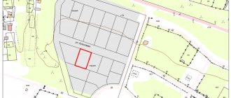
A situational plan of a land plot is a graphical diagram of a land plot and the surrounding area, made from above.
If you imagine a bird's eye view of the site, it can be considered a situational plan. The boundaries of the site itself should be visible, as well as its connection to a specific area. In addition, the situational plan indicates all objects adjacent to the site: roads, utility networks, public transport routes. The buildings marked on the plan must be accompanied by information about the date of construction, include street names, house numbers and the number of floors.
A situational site plan linked to the territory is obtained together with a copy from the general plan and is used for:
- Real estate transactions, when you need a complete understanding of the parties about the object and the surrounding area;
- Utility connections (electricity and gas);
- Planning the construction of a house and transferring the plan to the local administration;
- Reconstruction of historical monuments and determination of foundation displacements.
Sample situation plan of a land plot
When and why is it required?
Drawing up an SPZU is necessary in the following circumstances:
- demarcation of the territory and implementation of the demarcation plan;
- planning the construction of a residential, commercial or industrial facility to determine the available space and topography of the site;
- reconstruction of existing facilities while determining the presence of foundation deformation and the possibility of extensions and superstructures;
- connection of communications, incl. gasification and electrification of various facilities at gas stations;
- development of design documentation for terrain orientation;
- purchase and sale transactions to obtain complete information about the property;
- obtaining permission from local authorities for construction or installation of communications.
In addition to circumstances where an EPROM is necessary, there are situations where the document is simply useful and economically feasible. With it you can:
- calculate the illumination of the territory at different points and zoning the site;
- eliminate the risk of damage to underground communications when carrying out various works;
- determine the optimal options for the location of utilities, drainage systems, cleaning, etc.;
- ensure optimal use of the memory, taking into account its topography.
How to get a situation plan by cadastral number
Using the cadastral number of a land plot, you can easily obtain a situational plan in person. The service is provided free of charge. The execution time is no more than 3 days. The basis for refusal is the lack of necessary documents. If extradition is refused, you can appeal the decision in a pre-trial (out-of-court) manner.
To do this, you need to come to the nearest branch of the MFC “My Documents” with the following documents:
- An application in which you need to correctly indicate the cadastral number of the property (you will receive the form and sample on site);
- Passport of a citizen of the Russian Federation;
- An extract from the Unified State Register of Real Estate, in which you are indicated as the owner or tenant of the land plot.
Please note that in Rosreestr an extract from the Unified State Register costs 350 rubles (700 rubles for legal entities). If you want to get information cheaper, I recommend ordering a certificate through Quick Documents - this way you will receive a document for only 250 rubles. The order is completed within a day, the official data is from the Unified State Register of Russian Registers of Rosreestr.
Certificate from the Unified State Register of Real Estate, which I recently ordered through Quick Documents
Differences from cadastral and urban planning
In addition to the SPZU, the documents defining the location of the land plot include a cadastral plan (KPZU) and a town planning plan (GPZU). There are significant differences between them:
- SPZU includes all objects that currently exist, while GPZU is designed for the future and may not include a number of buildings. The purpose of the KPZU is to determine the boundaries of the memory itself.
- SPZU is characterized by a topographical basis. The KPZU is compiled according to the drawings of the cadastral passport and land surveying.
- Different scales are used for drawing up plans.
- KPZU is issued by government agencies, and the development of SPZU can be carried out by private companies and the interested citizen himself.
These plans serve different purposes and are negotiated in different ways.
Where to get a situation plan for gasification
In order to ensure gas supply to a home, gas supply services must be provided with a situational plan linked to the territory on A4 paper. Contact the gas service at your place of residence - they will explain which organization should issue a situation plan for your specific area.
To apply, you only need the exact coordinates of the site. If there are no such coordinates, then there are two more ways:
- Seek help from a specialized architectural organization that can take spot measurements and draw up a plan on a scale of 1:2000;
- Make a situational plan yourself. You can take, for example, high-resolution satellite images as a basis. We will return to the question of how to draw up a situational plan of a land plot for free. However, I recommend that you notify the organization for which you intend to prepare the document in advance of your intention to compile it yourself.
Where to get a situation plan for electrical networks
The situational plan for electrical networks is issued by the local administration. If there are no diagrams of energy-receiving capacities on the plan, they should be plotted by performing a topographic survey on a scale of 1:2000 or 1:500. The difference between such a situational plan will be that it must be certified by the performing surveyor, as well as the head of the inventory and cadastre service. In some cases, the plan must be agreed upon with the district architectural organization and local administration.
The situation plan for connecting electricity should show:
- A plot of land with existing boundaries;
- All buildings on the site, including utility and temporary ones;
- All power lines that provide electricity to each building to an external source of power supply;
- Types of protective equipment, grounding, brands, diameters and cross-sections of cables and wires, metering devices, points of connection to the network and design currents of internal and external circuits;
- Specification of electrical equipment, including materials and products.
Arbitrage practice
Disputes and conflicts between land neighbors are resolved through litigation. To establish the truth and restore violated civil rights, a situation plan is requested.
Knyashkin G.A. filed a lawsuit against his neighbors Savelyev. The defendants built a house on their site and, violating the development plan, built a sloping roof over a residential building. The accumulation of snow precipitation caused a one-time collapse, as a result of which the polycarbonate canopy of G.A. Kshnyakin collapsed.
One of the buildings on the Savelyevs’ property is used as a bathhouse; its location near the plaintiff’s house creates a fire hazard. The defendants also built outbuildings, entering the territory of G.A. Knyashkin.
The Buzuluksky District Court of the Orenburg Region ordered the Savelyevs to regularly clean the snow on the roof in winter, and also to compensate their neighbor for the cost of the canopy. The appellate court partially overturned the district court's decision and ordered the Savelyevs to demolish temporary buildings and a bathhouse.
How to download a situational plan of a land plot for free
It often happens that the customer tries to cope with the preparation of the document himself. People are trying to download a ready-made situational plan of a land plot by cadastral number online for free and print it. But I want to warn you that government resources are not available for free - plans on a scale of 1:2000 and larger are classified and can only be obtained by personally contacting the authorized body.
Possible solutions:
- Use aerial photos from Yandex or Google maps resources and independently draw the boundaries of the required area. It is difficult to achieve the required accuracy using this method. Most organizations do not accept such situational plans, but they can be used, for example, for commercial presentations or for their own needs;
- You can also use the website of a public cadastral map, but the plan will again be based on aerial photographs, which cannot always be used to prepare a plan;
- Develop a situational plan independently on a computer using special programs. This option will practically not differ from the plan prepared by professional surveyors, but requires technical skills. I propose to dwell on it in more detail.
Self-composition
If you have the desire and opportunity, formulate a plan yourself. To do this, you will need to perform the following steps step by step:
Drawing of the boundaries of the land plot on special graph paper with mandatory adherence to scale;- Display of all commissioned objects and those that are currently unfinished (in full accordance with their actual dimensions);
- Display of all located objects in the vicinity of the site;
- Fixing the cardinal directions with an indication of the wind rose, reflecting the prevailing directions of movement of air masses in a given area.
It is worth noting that a independently drawn up plan cannot be used for subsequent construction and the basis for planning structures.
How to draw up a situational plan of a land plot yourself
Step 1 - download the SAS.Planet program
On the website https://sasgis.ru/sasplaneta/ download the SAS.Planet program for free. With its help, you can pull almost any cartographic and satellite maps from the Internet in the form of source data. Since data sources are constantly updated, in addition to the installation file, you will have to download and install ZMP packages that ensure stable operation with updates to open data sources.
Step 2 - setting up and selecting a map source
SAS.Planet makes it possible to save any section of a satellite image into a file with the resolution required for the situational plan. For the resulting snapshot file, there are several binding options for MapInfo. The public cadastral map of RosReestr can be obtained with a resolution of 3-5 cm per pixel.
But you need to keep in mind that all sources of maps on the Internet (Yandex, Google, 2GIS, RosReestr) produce a raster exclusively in the transverse Mercator projection, and a cadastral map is a local coordinate system in the Gauss-Kruger projection with an exact indication of the central meridian and displacements along north-east. Therefore, for small areas of the situational plan, you can use manual snapping and rotate the image by a small angle without raster transformation. This will give some error, which can be corrected based on the results of geodetic surveying on the ground.
Step 3 - Raster Transformation in GlobalMapper
To avoid geodetic surveying, you can use precise mathematical referencing. Then a high-resolution raster will provide an accuracy of 0.5-2 meters on the plain and 3-5 m on rough terrain. To do this, you will need to transform the raster using the georeference file obtained from SAS in the GlobalMapper program.
Using a datum (PRJ), you can obtain a correctly transformed raster with an accurate georeference file already in the local coordinate system, and then load it into MapInfo. In this case, it becomes possible to even detect gross errors in geodetic surveying.