Construction of a house begins with drawing up a master plan for the land plot. The start of laying utility lines must be based on a package of permits, which includes a general plan. To draw it up correctly, take into account the properties of the terrain, the location of all buildings, fire safety requirements and coordinate this document with the BTI, administration and architectural department.
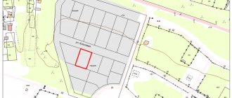
Example of a general plan of a land plot
What is the essence of the master plan
Russian Government Decree No. 87 dated February 16, 2008 states that this is a document containing land planning, site development, as well as any work that will be carried out on the site during construction. A document is prepared by superimposing a drawing of the future object on a topographic (photographic) base at a scale of 1:2000, 1:500, 1:200. The master plan can be drawn up for both an individual building and a microdistrict. The approved set of drawings of the plan being developed must have:
1. General information about working sketches.
2. Cadastral plan with plot dimensions.
3. Relief diagram.
4. Sectional drawing with soil layers.
General plan of the site in Moscow
5. Drawings of utilities - water supply, gas mains, electrical wiring diagram for the house, sewer system, etc.
6. Documentation for landscaping a personal plot.
7. Remote fragments – neighboring objects, roadways and other structures located nearby.
The registration requirements are the same throughout the Russian Federation. They operate both in Moscow and anywhere else in the country.
Work algorithm
1
You can send us a site plan, wishes for the location of the house and contact information by mail, WhatsApp, Viber or Telegram.
2
The specialist analyzes the information received, contacts you and clarifies all the necessary points.
3
You transfer us an advance payment of 50% in any convenient way - to a Sberbank card or current account, in cash to a courier or in our office.
4
We get to work. The specialist is always in touch - consults with you, explains unclear points, takes into account additional wishes.
5
After completion of the work, the paper version of the general plan is sent to the specified address anywhere in the Russian Federation and the CIS, the digital version is sent to your email.
6
You can pay the remaining amount to the courier upon receipt, or in another convenient way, just as you transferred the prepayment.
If corrections are required, we will make them free of charge. We will provide any consultations and help with advice.
Purpose of the document
A master plan is necessary for two reasons:
- Its preparation is a mandatory legal requirement, and without completed documentation, construction cannot begin. Compliance with established standards guarantees the safe operation of the building. Therefore, the master plan of a private house contains fire safety and sanitary requirements. Thus, in accordance with established standards, the gap between the walls of a residential building and the road should be 5 m, and the width of the canvas should be 3.5 m. Such requirements guarantee the free movement of equipment or fire trucks.
- Sketches and descriptions of work are a guide for construction. A properly designed project distributes buildings and auxiliary facilities throughout the yard. This is a complex that includes a residential building, a garage, a garden or vegetable garden, a swimming pool and/or bathhouse, etc. Therefore, when ordering even a standard project, you can propose your own changes.
Explanation of boundary approval
Advice: It is better to formulate a master plan for the land plot in parallel with the house design in order to provide for all the features of the area being built up.
Documentation for the planning of a future cottage (or other residential building) is coordinated with the architectural authority of the corresponding locality and its existing plan for the entire territory. To resolve any controversial issues, you must contact the administration.
What it is?
A land plot plan is a document that contains information about the land plots being formed, their parts, as well as new ones necessary for inclusion in the cadastre.
This is a drawing in which a certain territory is depicted in a reduced form using a scale. Such a drawing is the main cadastral document, which is formed during the land surveying process and is necessary to clarify the boundaries. It most often contains all the necessary information, including reference to the area and surrounding objects, both natural and built by man.
Consistent design of the master plan
The beginning of the compilation consists of collecting documents:
- House layout approved by the locality architecture service.
- Site drawing.
- The results of geological surveys, topographic and geodetic surveys - a general plan drawn up on a scale of 1:500.
- Requirements for connecting housing to centralized communications.
Minimum permissible distances between objects
Formation of the document is carried out step by step:
1. Deciding on specific buildings. At this stage, a list of objects is compiled, with their dimensions determined and the distance to the fence (or neighbors’ houses). Next, for each specified building, it is necessary to register, taking into account what sanitary standards its construction will be carried out.
2. Drawing of the appropriate scale: 1:500 or 1:20,000. The display size is selected based on the underlying basis used: situational, general or reference plan. The designed communications and relief characteristics are brought into compliance.
3. Making a decision on the placement of buildings on the territory.
Important: It is necessary to take into account slopes and dips in the terrain, normalized distances between objects.
Formation of a dendrological plan of the site and a drawing indicating other elements.
5. Making final adjustments as per the requirements of the home owner. After final approval, all the details are recorded on paper.
Why us?
- We have been making master plans of varying complexity since 2006, the minimum professional experience of our specialists is 10 years.
- All employees have specialized education and the highest qualifications in their specialty.
- Clear knowledge of the legally regulated theoretical basis for the location of residential buildings.
- Individual approach to each customer, free consultations, we take into account all wishes and nuances.
- We work without intermediaries - no overpayments or markups, the best cost of services on the market.
Documents for the formation of a master plan
The following are used as the basis for its preparation:
- cadastral plan of land for future buildings. On such a diagram, the boundaries of the site are defined and there is a graphical representation of it;
Graphic display of the area
- a description of each of the possible buildings erected;
- a diagram showing all objects in the adjacent territory, the roadway;
- situational plan. This is a site location map. The name of the locality, region and country must be indicated here. It looks like a photo from space;
- reference plan. This is a kind of diagram indicating all construction projects in the yard, green spaces;
- drawing of utilities: sewerage, electrical connections, gas pipeline, water main, indicating the points of entry into the building;
- diagram of preparatory operations on the site with highlighting elevations.
Sample situation plan
Nuances during formation
Please note that:
- You cannot plant tall trees and build houses where communications are located;
- if the soil is prone to waterlogging, the area should be provided with a drainage system;
- on uneven terrain, it is better to build buildings at some elevation;
- When building a house on a slope with a slope angle of ≥ 1:2, it is recommended to strengthen the soil with supports, and also to plant trees with a deep root system nearby.
Building base
The next tool on the Forms and General Plan command bar is Building Base . In the “Drawing” section, you can use any of the proposed tools to create a sketch. It is important to note that the base is created with the slab already in place, and the toposurface is adjusted to the contours of the slab.
Sample master plan
The figure shows a standard example of developing a personal plot on a scale of 1:500. Structures and plants are indicated here, details of the terrain, sidewalks and garden paths, entrances for vehicles, etc. are reflected. The more details and details there are, the easier it is to carry out further work.
Although the cost of the document is high, it is mandatory to have it. Otherwise, the entire process will subsequently be declared illegal by the urban planning department.
Architectural passport
The house project passport is not included in the complete kit; it can be purchased for an additional fee.
The architectural passport of the project makes it quicker and easier to obtain a building permit, as it contains all the documents necessary to submit to local architectural authorities.
Composition of the architectural passport:
General project data
Plans in axes
Facades
Cuts in axes
Roof plan
The “Construction Project Passport” cannot be sold without purchasing the main set of working drawings.
You can also purchase an additional set of drawings (hard copy), which is usually necessary for builders.